SEXTANT/Virtual Planning Tool was developed to support the dismounted warrior's planning and preparation for conflict & action in urban areas. It provides the user a workable mission planning tool with a minimum of data available. 2D and 3D planning can begin with little more than a satellite photo if need be. The software can also harness the vast array of geospatial data available for use in the planning. The tool provides the user with a virtual sandtable on which to plan the mission and then rehearse the mission as planned with both 2D and 3D visualization.
The system deals with information about simulated dynamic objects (such as units or vehicles). The system keeps a location history for each object, so movement can be plotted on the map over time. Static geo-referenced information such as fortifications and buildings can also be plotted.
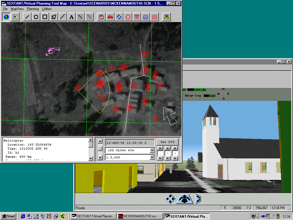
The map display consists of a global grid to which the system refers to locate geo-referenced information on-screen, and a background map. The raster map backgrounds and vector map data refer to the grid to be displayed appropriately. This way, even if the system has no map data, other geo-referenced data can still be shown. The system can display geographic data based on any datum or ellipsoid, given appropriate transformations to align it with the grid. This flexibility allows the user to choose the most appropriate type of map (geographic) information for their application. Zoom, scroll and move options are available for the map display.
Map icons provide direct access to the state of simulation objects through a point and click interface. Objects can also be accessed through conventional text-based browsers (opened from a menu on the object of interest). There is a connection between the text browser and the map icons, so selected icons on-screen are also selected in text lists, and vice versa. Each icon type has its own appropriate menu. Layers of similar icon types are managed by the system so the user can choose which types of icon to view.
The system includes a force layout tool (for both enemy and friendly forces), and a weapons database. The forces can be arrayed on the map display as can the weapons. The mission plan is built up for each time phase of the planned battle, with appropriate annotations made to the map at each phase, and units moved to their planned locations. The time phases of the plan can be stepped through and viewed in 2D. The 3D visualization is a real walkthrough of the site (modelled prior to the engagement, or a rudimentary one generated on the fly from objects placed in 2D). All 3D objects are real, so the user can enter buildings and look out windows.
The system provides access to geographic data (ground height) so lines of sight can be determined and displayed both on screen and as path profiles. The height data is also used to determine weapons range fans.
Object Raku are interested in collaborative work to define an appropriate shard plan representation to allow for interfacing between planning systems and their visualization/rehearsal facilities in Sextant VPT.
There is a knowledge base framework in the system. It has been used to create an Expert Analyst which, based on predefined rules, can determine various things about the situation (carries out situation assessment and tries to determine enemy intention) from the raw electronic warfare data coming from sensors. It is based on CLIPS.
The system has the ability to track, in 2D, position data from attached sensors. The software is flexible and could deal with a relative coordinate positioning system.
The 2D planning system allows display of planning data including red and blue forces, map backgrounds, imagery, weapons placements, various vector data, and is optimized for military operations in urban terrain. A networked mode is possible, as the precursor (electronic warfare system) transferred the situation assessment data between remote locations over combat net radio. All communications were minimal bandwidth (using combat net radio as the transmission medium).
There is an associated 3D visualization tool (Superscape/Visiscape). The 3D scene is built on the fly with data from the 2D planning system. Once built (and during building) the scene can be walked through. A networked mode is available (optimized for use on the internet) so remote users can interract using the same scene.
There is a mission rehearsal tool consisting of the 2D planning tool and its associated 3D visualization and walkthrough. The 2D planning tool has knowledge of time, so various phases of the mission can be set up for the times at which they occur. The mission can then be stepped through on the map. The mission can also be walked through in 3D.
Integration with a planning agent could give users a real support tool that could recommend courses of action, as real-time position information was coming in. The collaborative nature of planning could be supported using the networked modes of operation.
Arcview/Arcinfo compatibiliy is high on Object Raku's list of priorities. The adoption of OGDI (Open Geospatial Datastore Standard) is anticipated to support armed forces standards and some commercial systems interfacing.
There are several options for interconnection between the AI planner and the Planning Tool. The planner needs to access the tool to getTerrain, getMapInfo, getSketchInfo, getEnemyInfo, getFriendlyInfo, getWeaponInfo and to setOverlay. This is a basic protocol, and no limit is implied (Notes from Janette Hooper, Object Raku Technologies, 24-Feb-99).
The first and most accessible to both applications is a Web based interface. If the planner could generate the requests in an HTML form, SEXTANT/VPT could process the request and provide the response also in an HTML form.
SEXTANT/VPT can also read and generate standard files for georeferenced information such as .shp files, through the OGDI standard. This would be an appropriate mechanism for the planner to pass an overlay for display by SEXTANT.
A direct TCP/IP connection with our own agreed upon data format is a possibility (probably more work than the web-based interface) and the data format could be using standard formatted messages (such as USMTF) which SEXTANT can parse.
It is possible to use an Object Request Broker (CORBA 2.0 compliant) as an ORB exists that is easily interfaced to SEXTANT and is available for both Windows NT and UNIX Solaris.
Microsoft Office if orders and synchronization matrices are to be produced/viewed in Word and Excel. Other required software is bundled with the SEXTANT licence.
The Object Linking and Embedding (OLE) standard will be used by employing ActiveX components for use by the application, rather than re-implementing functions. In particular, the company will integrate some of the MapObjects ActiveX controls (ArcView 3.1) into the SEXTANT/Virtual Planning Tool. The company will also integrate the Superscape 3D control ViScape into SEXTANT for the 3D functionality, harnessing the power of a 3D gaming engine.
Several Smalltalk API's will be used: Open Geospatial Datastore Interface (OGDI) for accessing data and the GeoSym and Common Warfighting symbology standards for symbol display.
Several DLL's in C and C++ (one for reading ADRG maps, one for reading CGM files) used by the Smalltalk code.
ActiveX components.
Version 1 is currently available and includes all features in the current demo (using DDE rather than the embedded OLE for intercommunications between 2D and 3D aspects of the application).
Version 2 available in May 1999 will transition to embedded OLE and full use of the construction by parts paradigm available with VisualAge Smalltalk. It will include a help wizard to walk the user through the planning process, integration of the orders and synchronization matrix to produce template plans, and more 2D to 3D interactivity for the mission rehearsal process.
Version 3.0 available in December 1999 will use the Open Geospatial Datastore Interface for accessing data and the GeoSym and Common Warfighting symbology standards for symbol display.
The work on SEXTANT/VPT is currently being supported by the Military Operations in Urban Terrain (MOUT) ACTD, Requirement 40 (Mission Planning and Rehearsal) through STRICOM Orlando and SSCOM. It will be included in Army Experiment 6 in May 1999 at Ft Benning GA.
Army Experiment 4 (MOUT ACTD) at Fort Benning for Requirement no. 40 (mission planning and rehearsal) gave feedback on the use of Sextant VPT. This included suggestions of improved plan library use, plan creation wizard support, support to the planning and order dissemination process, etc. This would be a good fit between Object Raku's work and AI planning and intelligent Process managemet technologies.
A future enhancement that the users wanted is the ability to add in model detail for interiors of buildings. This is possible now, but automated support for 3D interior creation from AutoCad files is planned.