HPKB Sketch Tool
Description
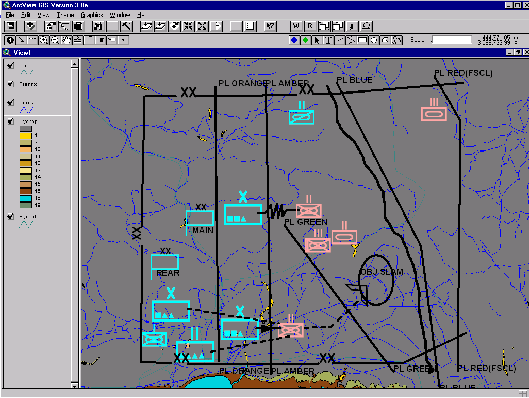
A Plan Sketch Tool from the DARPA High Performance Knowledge Bases (HPKB)
Program. This tool allows the user to sketch Division-level COAs. It
is based on a commercial GIS tool,
ArcView,
and has been customised to provide the user with a palate of
standard military symbols.
The intended use of this tool is as an input device to a knowledge-based
system. The information represented in the sketch is automatically
translated into a knowledge representation language. Planners require
similar descriptions of scenarios.
History/Roots
The HPKB sketch tool has been under development since 1998. The
knowledge representation format it produces is intended for use
with the
Cyc
knowledge-based system, but will be translated for use by
other participants in the HPKB program.
Role
A front-end to a knowledge-based planning and reasoning system.
Capabilities for the Planning Process
Its capabilities with respect to planning in
Verb/Noun Phrase format are:
PROVIDE PLAN OBJECTIVES AND REQUIREMENTS comprising:
- units, unit echelon, specialisation, and location,
- task assigned to unit and any location change,
PROVIDE CONSTRAINTS on plans comprising:
- geographical features, e.g. cities, rivers, mountains,
- and significant obstacles, e.g. minefields.
Interconnectivity and Shared Models
This tool is currently interfaced to Cyc, interfaces to at least two other AI
systems are being developed.
Relevant Scenarios
This tool has no known SUO scenario, but should be capable of reading
a GIS survey of any site.
Contacts
Machine, OS, and software requirements
Needs ArcView GIS version 3.0a. Available on PC/Windows NT 4
(tested), Apple Macintosh MacOS (tested) and Unix (not tested).
Implementation Languages
ArcView 3.0a Script Language - Avenue.
Scripts are portable across all ArvView platforms (PC, Mac, Unix).
Availability
Potentially available for US governent purposes
as a product of the DARPA HPKB program.
Web Resources
Comments
This tool is not designed to display plans generated by another
tool. This would only be possible if the plan were represented in the
ArcView file format. The output of the sketch contains no
temporal information about the sequence of events, that information is
derived from the textual representation of the COA.
John Li (jli@teknowledge.com)
of Teknowledge notes:
- The sketch tool was designed for sketches of COA at several echelon
levels, including division, brigade, regiment, battalion and company.
It can be altered to work at even lower levels;
- The sketch tool was developed with the ArcView script language -
Avenue. The result is a very flexible system with a very small footprint,
compared to other heavy-weighted systems such as ModSAF;
- ArcView and other ESRI products (map and tools) can provide more GIS
information and analysis if needed. Information can be transmitted to and
from ArcView to other systems through sockets or other telecom protocols.